
- Circulation

Highways, streets, roads, boulevards, avenues, alleys, the names and function may vary but their primary concern is to allow access and movement from point to point.
These forms of circulation, as a rule, are drawn in the same standard format on maps for their individual countries. This is then described in a key within the map. The hierarchy of these forms of circulation varies and can be labeled as the following.
Freeway
Freeways are high speed, multi-lane facilities with a high degree of access control. These facilities provide for efficient and uninterrupted travel over long distances serving interstate and commuter needs. They should provide a high level of traffic service for travelers making longer distance trips at high speeds. Freeways provide no direct access to abutting properties.
Principal Arterial
Principal Arterials serve the needs of through traffic for moderately long trips. They serve the major activity centers in the County and major portions of the trips entering or leaving urban areas. Principal Arterials are the primary travel route for commercial, commuter and recreational travel in rural areas. They also provide secondary linkages between large urban centers and suburban population/employment centers. Access may be controlled through medians or by the limitation of curb cuts through the orientation of access for new developments. Typically, they intersect minor arterials, collector or major activity locations.
Minor Arterial
Minor Arterials connect higher functional class facilities, activity centers, regions of the area, and major county roads. Traffic is composed predominantly of trips across and within regions of the city. They provide service to traffic at a somewhat lower level of travel mobility than principal arterials with minimal control of access to abutting commercial, industrial and residential properties. Direct access to individual properties and neighborhoods is discouraged.
Collectors
Collectors provide traffic circulation within neighborhoods, commercial and industrial areas. These roads collect traffic from local streets in neighborhoods and channel it into the arterial system. Connections between arterials should be indirect or should not be allowed in order to discourage use by traffic from outside the neighborhood.
Local Roads
Local roads are designed specifically to have high accessibility to abutting land and access to the higher classification facilities. They offer the lowest level of mobility and service to through traffic usually is deliberately discouraged.
Historical Forms of Circulation
The general difference between a circulation route within the city fabric then that of the countryside is urban circulation is formed primarily by building mass. To understand the western form of the urban street a brief historical overview is required. Note: the urban street is rarely an isolated element and is commonly seen as a possible ensemble of streets, spaces, and monumental buildings.
The Roman Empire road, known as viae, was developed to move armies and goods and allow communication as the empire expanded. The technology allowed some roads to survive today. To fabricate the roads the Romans used cut stones set in a curved direction to allow drainage, set these on a mixture of cement mixed sand and broken tiles, which was set on a foundation of stone and gravel.


Medieval Roads
This period encompasses a series of different road, or street types. Originally you have roads (paths) occurring as a by-product from people traveling along specific routes.
There are situations though where straight streets do occur during the medieval period. Examples are where buildings built on the foundation of earlier Roman towns, i.e. Via del Corso, which is the original Decumanus road for Florence, and later medieval new towns, i.e. any street in the old part of Grenade-sur-Garonne, France.


Renaissance Streets
The primary straight street is a Renaissance innovation. In the majority of instances, it still provided the approach to buildings, and frequently had direct connections with regional routes, but its main function was to facilitate movement, increasingly by carriage, between parts of the city.
One of the key tools in influencing the urban design of the renaissance was the introduction of the perspective. In the medieval or gothic period of urban cities the organization of the buildings, which bordered typically were haphazardly placed and would contest for space. The renaissance street, in contrast, became a somewhat of a stage set, with buildings composed to enhance the perspectival view, designed as a whole architecture.

Right, set design by Sebastiano Serlio, “Tragic Scene”, from the “Five Books of Architecture,” 1537
Sixteenth-century Genoa produced a distinctively new type of urban space in the Strada Nuova. The residential palace street, or linear piazza, was developed to legitimize and heighten the authority of a ruling elite.
Laid out in 1550-51 and built between 1558 and 1591, Strada Nuova, (later known as Via Garibaldi) is 250 meters long and 7.5 meters wide.
When taken as a whole, Strada Nuova represents significant themes for the history of Genoa and the interpretation of Renaissance cities. This major example of Italian Renaissance architecture and urban planning was conceived, and indeed, functioned as a classical stage like space for the old nobility, who governed and controlled the tightly restrictive Genoese aristocratic republic of 1528.
“This scenographic urban enclave proclaimed the exclusive social, economic, political, and ceremonial position of the old noble families who commissioned ostentatiously rich, decorated palaces along the Strada Nuova’s central, monumental perspective axis. As such, the Strada Nuova became the major public presentation space for the regime these families led.”
Gorse, George, “A Classical Stage for the Old Nobility: The Strada Nuova and Sixteenth-Century Genoa,” The Art Bulletin 79 (1997), pp. 301-327


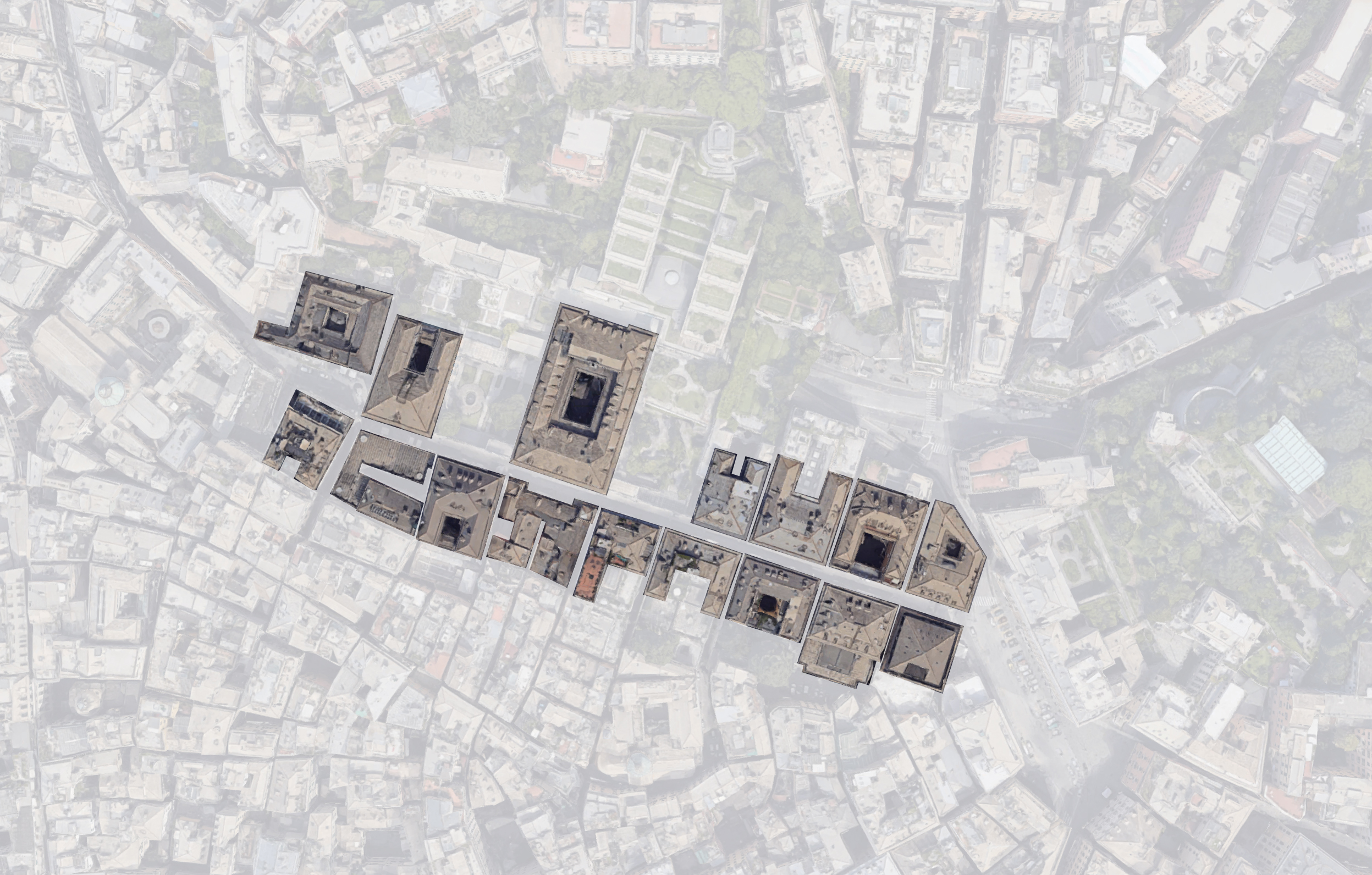
The Uffizi in Florence is another designed street of the Renaissance. Designed by Giorgio Vasari in 1560, it was completed in 1581. The Uffizi is essentially a cortile and is connected to the Piazza della Signoria on one end, and to the Arno River on the other end. Many architectural historians considered the Uffizi the first regularized streetscape of Europe, due to its repetitive bay design.


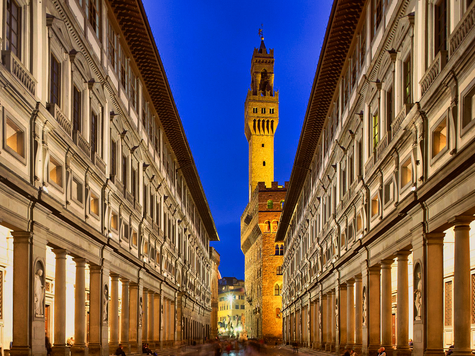
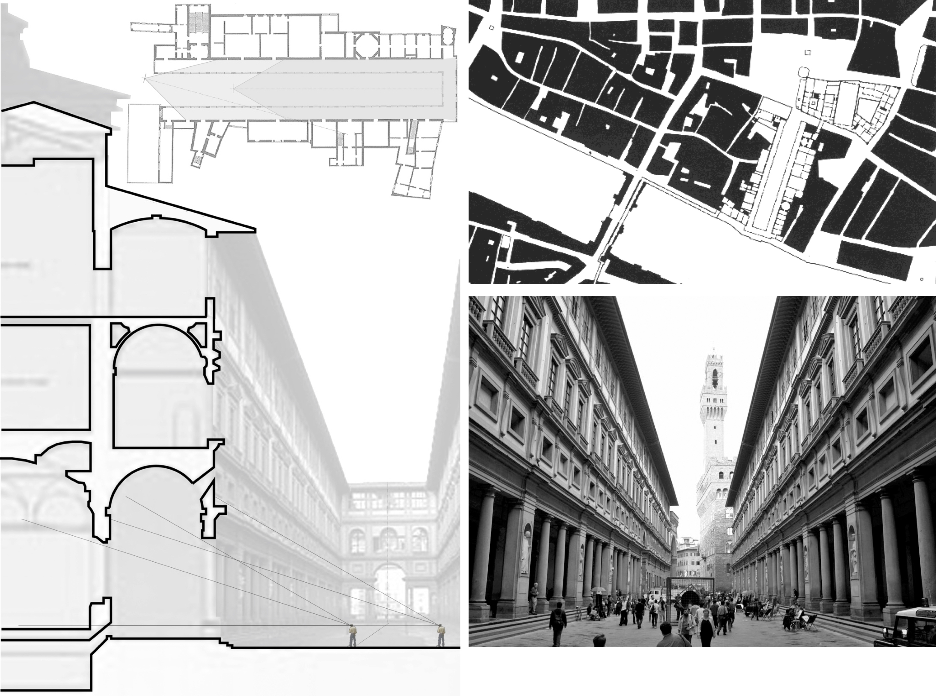
Another aspect of the Uffizi is the loggia. The archetype of the loggia, meaning an open-sided roofed or vaulted gallery that is either freestanding or positioned along the side of a building, proved to be an effective device for mediating between severe office architecture and its surroundings.
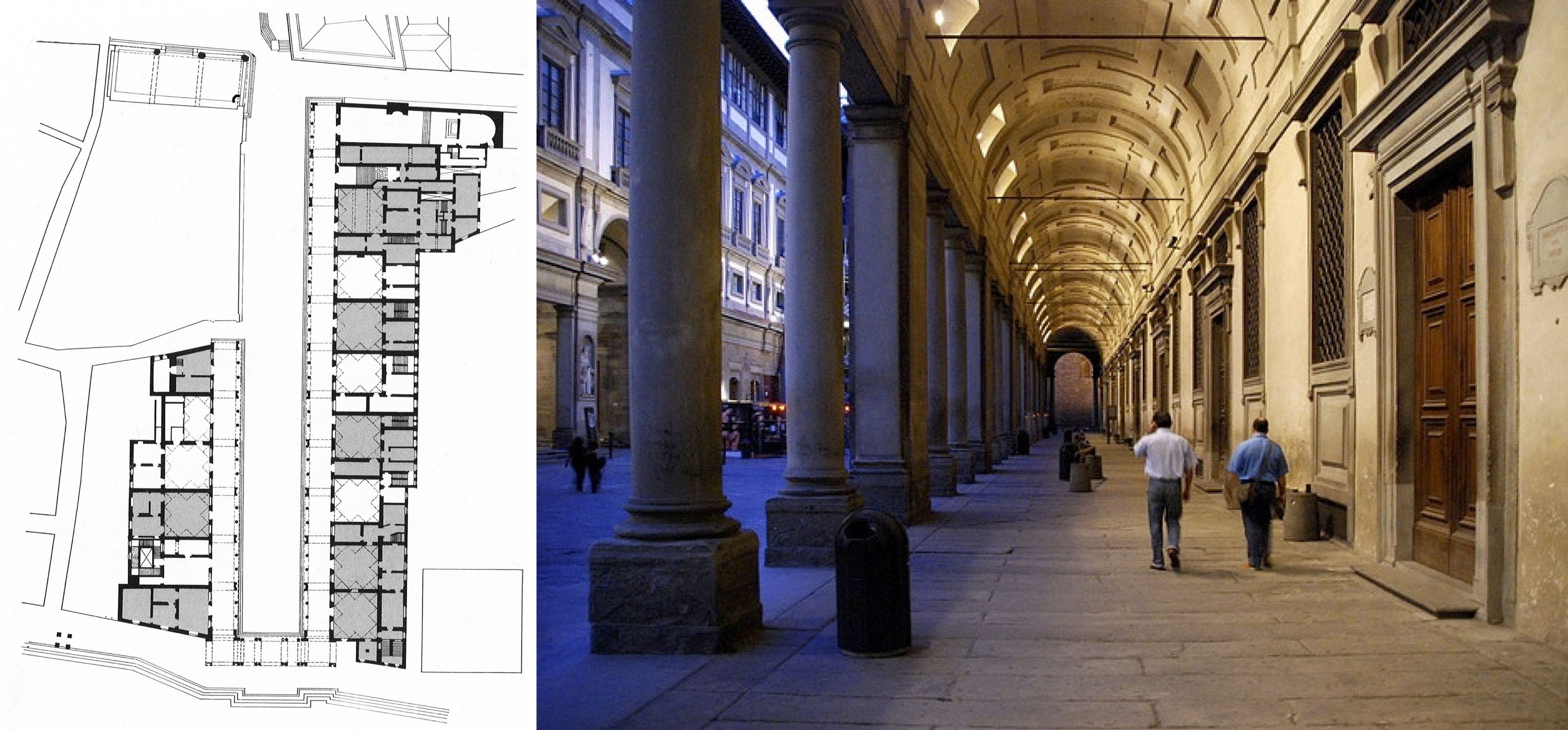
“In the vocabulary of the urban forms, in fact, the loggia can be considered as the opposite of the city wall: it does not include or exclude anything, but rather creates a space in which to frame and “measure” people, movements and goods, thereby modifying the very contextual conditions in which it is placed “from within” as a sort of internal threshold. An office structure with a loggia thus presented a perfect synthesis of the two main types of power: the political and the managerial, or the representativeness of the State and the effectuality of its governance.”
The Office and the Loggia: Giorgio Vasari’s Architecture for Bureaucracy
Francesco Marullo – August 19, 2012
The Influence of Pope Sixtus V
“The city of Rome significantly shrunk in size during the Middle Ages from its ancient classical stature. The result was a severely diminished urban core concentrated in a small area at a bend in the Tiber River. The population decreased from over a million individuals to less than 17,000 people huddled together in this small urban core (Rogers 2001:149). The city walls encircled a much larger area and contained the classical ruins of ancient Rome as well as seven churches that were the foci of annual pilgrimages by worshippers. The city was an unorganized collection of structures and destinations connected by footpaths that meandered over the countryside between the landmarks” (Rogers 2001:149).
As the Church in Rome gained more power during the beginning of the Renaissance period it became necessary to position Rome as a cultural and religious center in the world. Several Popes following the middle ages began to assert power and help the make this shift (Newton 1971:146). Several important streets were straightened to assert organization and building height restrictions were instituted to maintain the physical dominance of the churches in the landscape.
Other improvements were made that began to organize city spaces such as the Michelangelo’s masterpiece of urban design at the Piazza Campidoglio and the broad street known originally as Via Pia, known today as Via Settembre (Rogers 2001:151). However, as of 1585 when Sixtus V became pope, only Michelangelo’s design demonstrated an attempt to organize more than one building spatially. While these attempts made significant impacts, they were largely uncoordinated single actions when compared to the impact made by Pope Sixtus V (papacy 1585 – 1590).
Cardinal Montalto, an exiled religious leader, had developed ideas for reorganizing Rome before he became Pope Sixtus V. He wanted to reinvigorate the city and create a place suitable to be the center of the Christian world. Using the entire city, Pope Sixtus V overlaid an organizational structure for circulation routes that connected major spaces and structures by means of an element that would literally establish points in space that would be difficult to be taken away (Bacon’s “Design of Cities”1967:131).
Classical Rome was a collection of monumental architectural structures that did not consider spatial relationships or circulation issues. Sixtus V introduced a new way of thinking about the city by articulating circulation as organizational structure. Edmund Bacon attributed the emergence of the spatial thinking required for the realization of the plan envisioned by Pope Sixtus V to the development of perspective drawing in the first half of the fifteenth century. This visual aid allowed design to include movement through space as experiential sequence instead of individual static elements in space.
Bacon said it was “not manipulation of mass but as articulation of experience along an axis of movement through space” (Bacon’s “Design of Cities” 1967: 123). Pope Sixtus V developed a plan for Rome that organized the whole city around several key points in space that relate to each other over the expanse of the city. Utilizing major landmarks, he located 4 obelisks across the city that allowed clear visual connections and movement between them. This established a framework for future development that is visible in Rome today.

This did more for Rome than any single building project could have ever accomplished. It provided a simple and understandable framework for future building that would continue long after his papacy. Most of the work that is visible today in Rome that was a direct result of this vision was constructed after his death in 1590. The pattern he developed was based on providing a clearly defined circulation pattern for the destinations of the pilgrimage to the seven churches of Rome that were scattered about an open, undefined landscape. The realization of his plan was not due to his individual power as a Pope to influence design and building in Rome but was due to the clarity of the message delivered in the few small, simple projects that he completed.

The idea of relocating several existing obelisks to key locations helped to direct the development of circulation paths between them in straight avenues that converge on the obelisks but also influenced the space that surrounded each one and along the connecting paths.
(For further reading: Engineering the Eternal City: Infrastructure, Topography, and the Culture of Knowledge in Late Sixteenth-Century Romeby Pamela O. Long)
Baroque Streets
One of the first grand ideas of Urban Baroque is the axis, first introduced in Italy with garden design. The idea of the long perspectival axis (or allé) existed for some time in the form of the linear hunting paths, usually contained with the grounds of a châteaux.
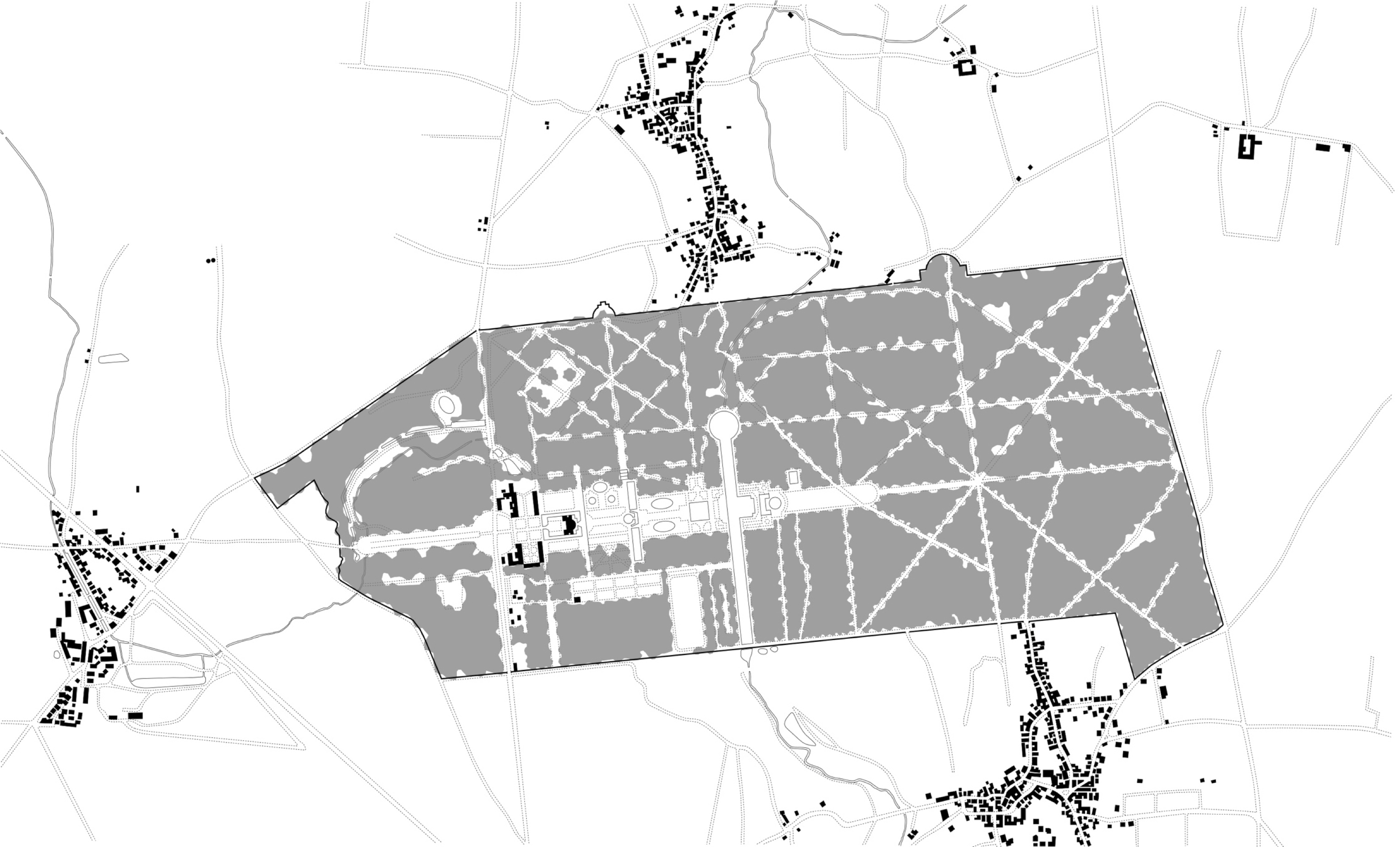
The long baroque axis, or ‘grand axial vista’, first appears in France with the design of the Luxembourg Gardens in 1620, and in the gardens of Chateau of Vaux-le-Vicomte. Built in 1658-61 for Nicholas Fouquet, the finance minister of Louis XIV, the gardens of Vaux-le-Vicomte were designed by André Le Nôtre. Shortly after the opening celebrations of the chateau Fouquet was jailed, and Louis XIV afterwards employs the designer, Le Nôtre, for his palace and grounds expansion at Versailles.

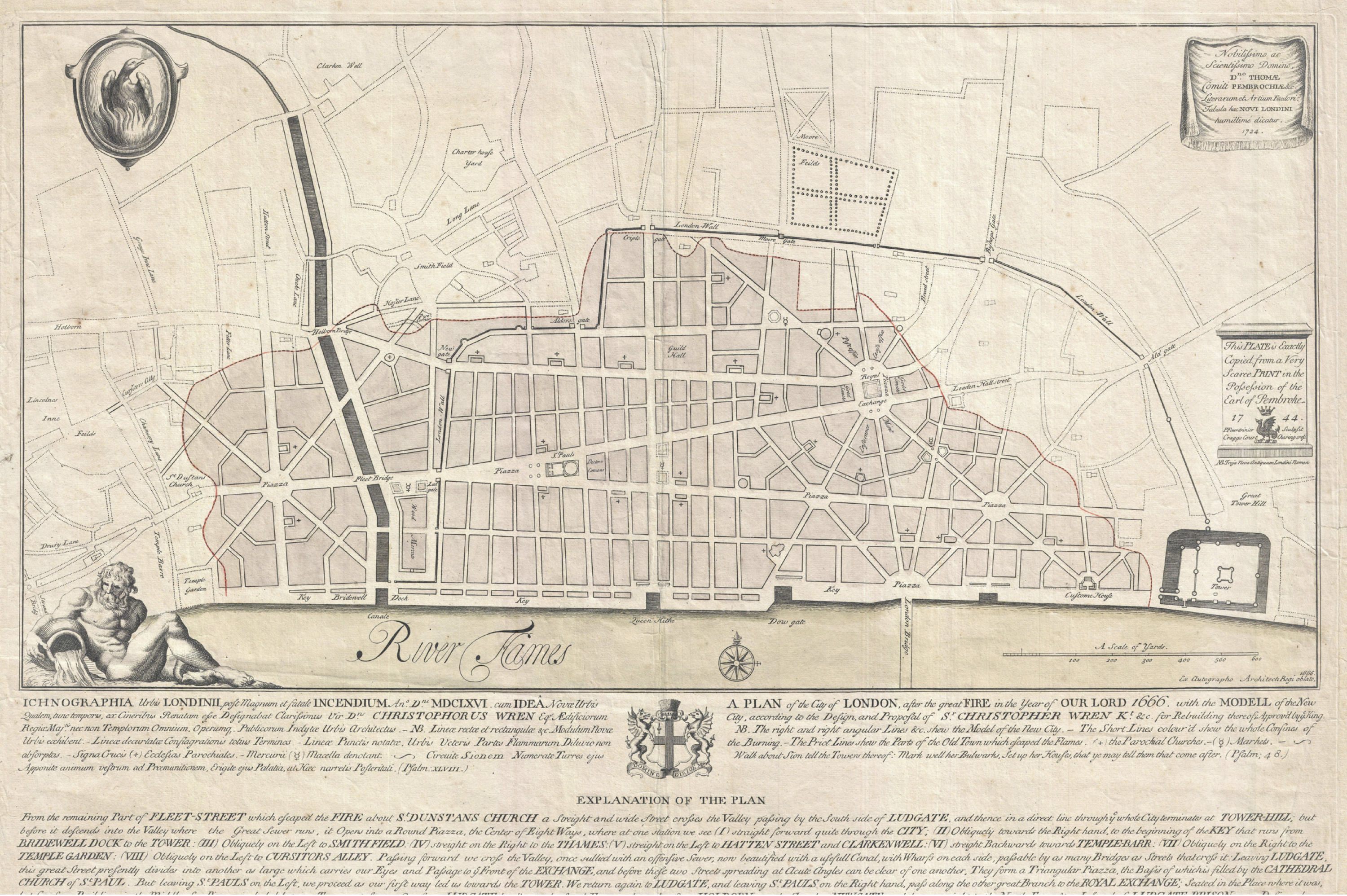
In 1666, after the great fire of London, and within a few days of the fire’s end, Christopher Wren submitted plans to Charles II for the complete rebuilding of the city. Similar to the long axes found in Vaux-le-Vicomte & Versailles, Wren’s grand scheme called for cutting wide avenues through the former maze of alleys and narrow roads that had made up old London. His proposal would open up the city to light and air. King Charles liked the scheme, but he realized the expense and the necessity of rebuilding the burnt-out areas as fast as possible made it the scheme unworkable.
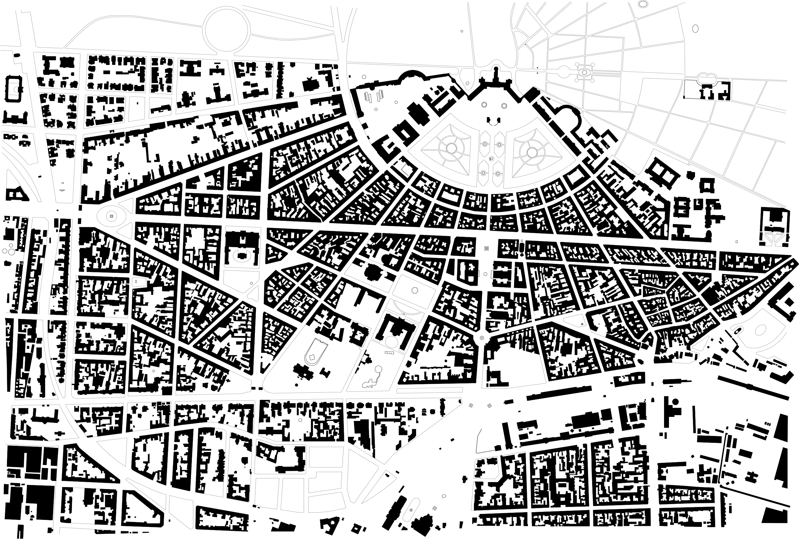
Karlsruhe is a major example of baroque urban planning. Founded in 1715, the structure of the city was defined largely by the city’s founding father, the margrave Karl Wilhelm, and the architect and town planner, Friedrich Weinbrenner, who was the son of a Karlsruhe carpenter. When he returned home in 1800, after spending six years studying in Rome, he was commissioned with the expansion of his native city. The palace acts as the center for a series of fanned streets, which are then fixed by a crossing grid.
The Boulevard (or Avenue)
A boulevard or avenue is usually a wide, multi-lane arterial street, divided with a median down the center.
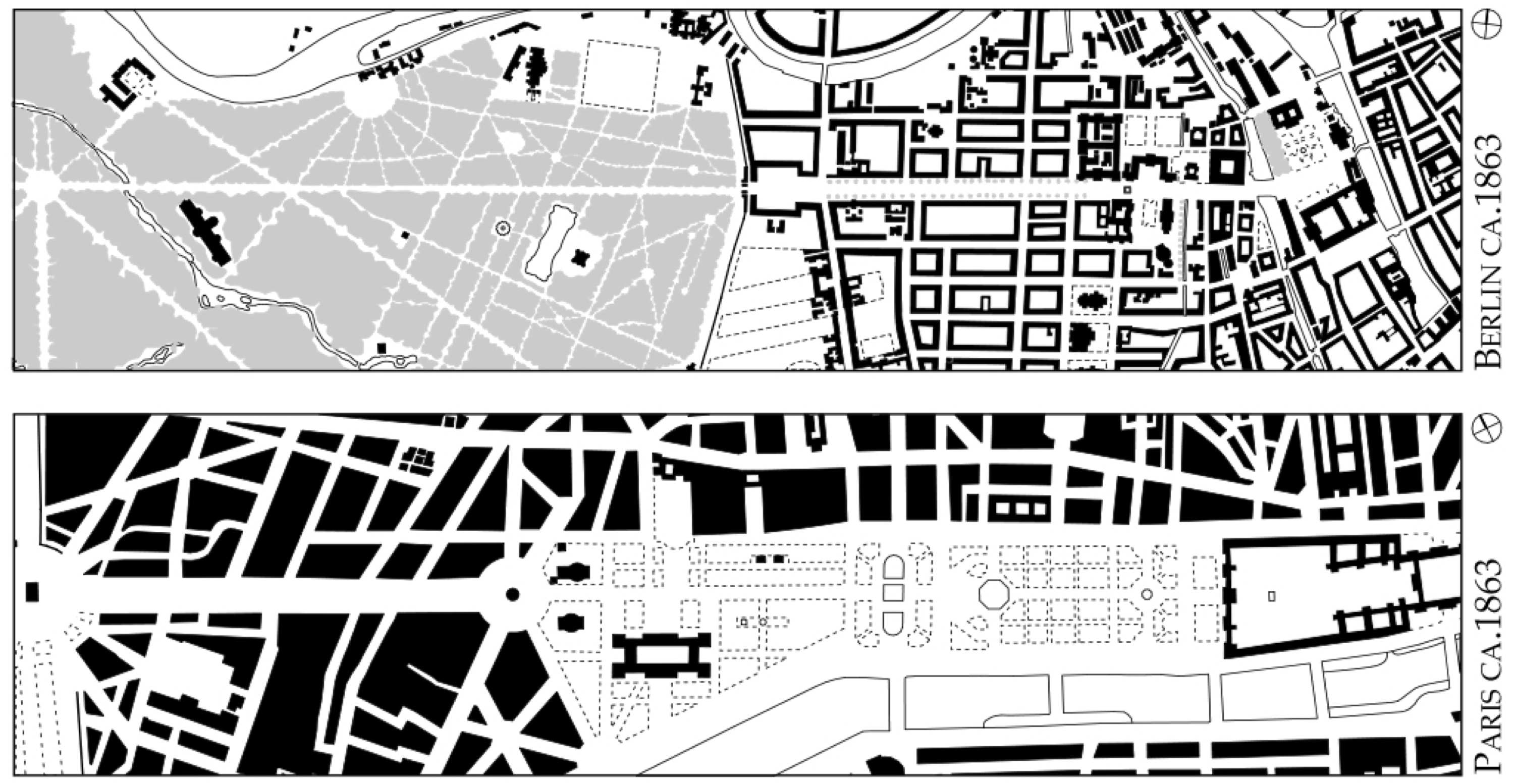
One of the most notable additions of boulevards to a city is Georges-Eugène Haussmann renovation of Paris. “Haussmann’s renovation of Paris was a vast public works program commissioned by Emperor Napoléon III and directed by his prefect of the Seine, Georges-Eugène Haussmann, between 1853 and 1870. It included the demolition of medieval neighborhoods that were deemed overcrowded and unhealthy by officials at the time; the building of wide avenues; new parks and squares; the annexation of the suburbs surrounding Paris; and the construction of new sewers, fountains and aqueducts. Haussmann’s work was met with fierce opposition, and he was finally dismissed by Napoleon III in 1870; but work on his projects continued until 1927. The street plan and distinctive appearance of the center of Paris today is largely the result of Haussmann’s renovation.” Wikipedia